
Your web browser is no longer supported. To improve your experience update it here
Australian weather forecast
National weather
Rain Radar map
18:40 AEDT18:45 AEDT18:50 AEDT18:55 AEDT19:00 AEDT19:05 AEDT19:10 AEDT

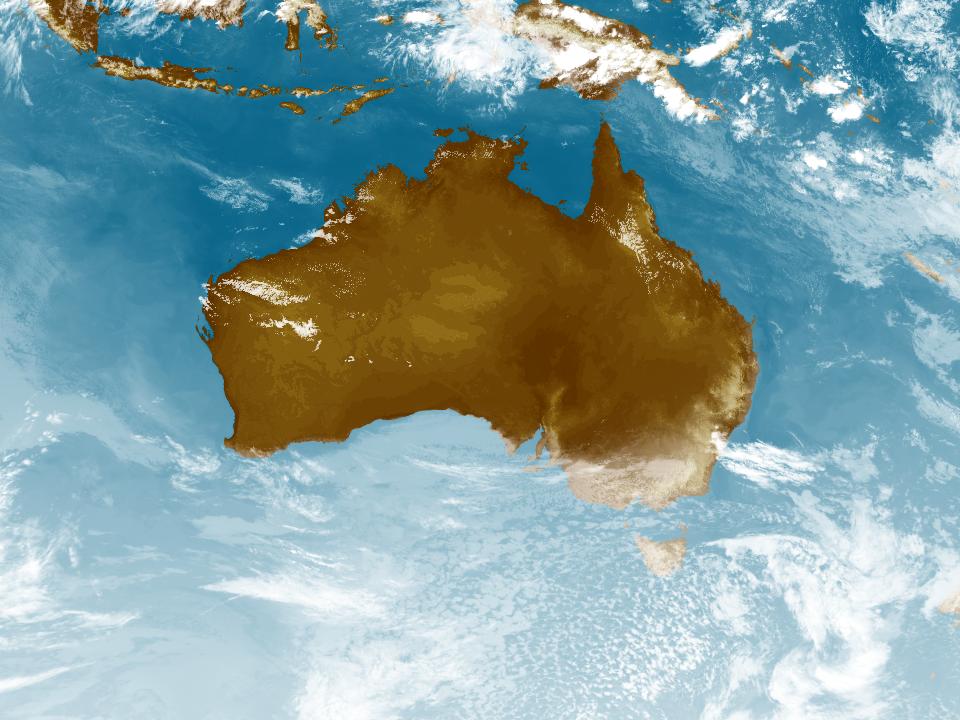
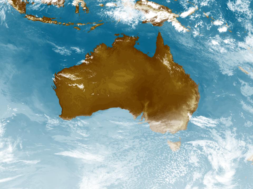
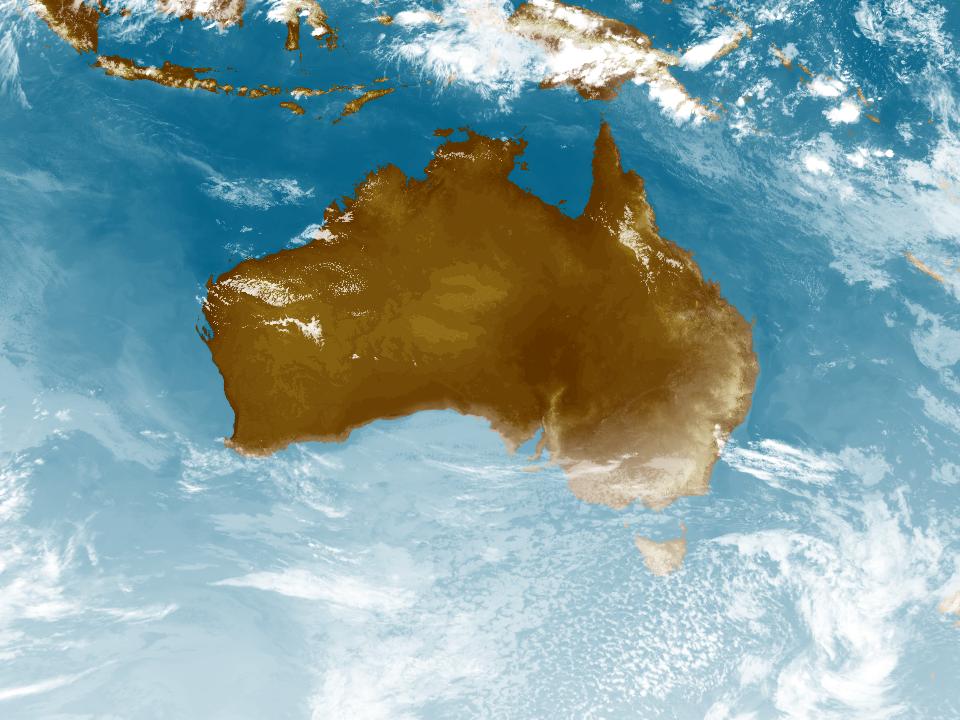
Weather Satellite
17:50 AEDT18:00 AEDT18:10 AEDT18:20 AEDT18:30 AEDT18:40 AEDT18:50 AEDT


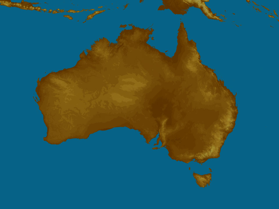
Synoptic weather chart
View national synoptic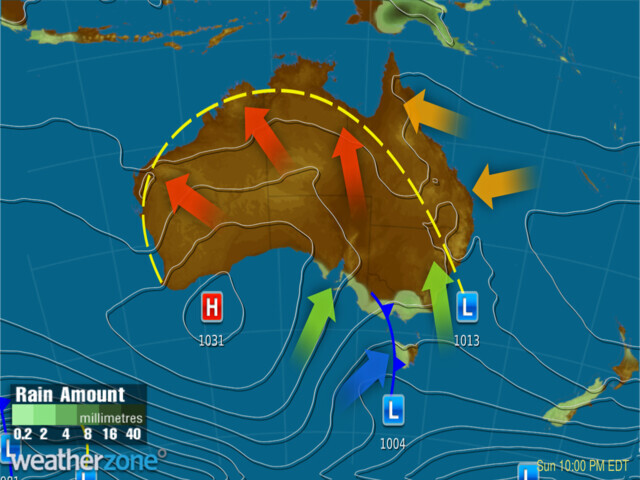
Sunday 12:10 EST
A deep low & cold front should bring gusty showers to southeast SA, coastal Vic & western Tas. Other troughs will drag warmth into northeastern NSW, QLD, WA & the country's north, bringing the odd shower to eastern Qld & WA. A high will keep conditions clear across the interior.
Issued Saturday 02:10 EST
Weather warnings
Sheep Graziers Warning for Midlands, Upper Derwent Valley, South East & North West and East coasts
Australian Government Bureau of Meteorology Tasmania Warning to Sheep Graziers for North West Coast, Midlands, East Coast, Upper Derwent Valley and South East forecast districts Issued at 06:41 PM EDT on Saturday 14 October 2023 Warning to Sheep Graziers for the following areas: North West Coast, Midlands, East Coast, Upper Derwent Valley and South East forecast districts Sheep graziers are warned that cold temperatures, showers and westerly winds are expected during Saturday and Sunday. Areas likely to be affected include the Upper Derwent Valley and South East forecast districts and parts of the North West Coast, Midlands and East Coast forecast districts. There is a risk of losses of lambs and sheep exposed to these conditions. The next warning will be issued by 11:00 pm EDT Saturday.Cancellation of Sheep Graziers Warning for South West, Central and West and South Gippsland
Australian Government Bureau of Meteorology Victoria Cancellation of Warning to Sheep Graziers for South West, Central and West and South Gippsland forecast districts Issued at 06:39 PM EDT on Saturday 14 October 2023 Cancellation of Warning to Sheep Graziers for the following areas: South West, Central and West and South Gippsland forecast districts The Warning to Sheep Graziers for the South West, Central and West and South Gippsland forecast districts has been cancelled. No further warnings will be issued for this event.Sheep Graziers Warning for Southern Tablelands and Snowy Mountains. Cancellation of Sheep Graziers Warning for Central Tablelands
Australian Government Bureau of Meteorology New South Wales Warning to Sheep Graziers for Southern Tablelands and Snowy Mountains forecast districts Issued at 06:37 PM EDT on Saturday 14 October 2023 Warning to Sheep Graziers for the following areas: Southern Tablelands and Snowy Mountains forecast districts Sheep graziers are warned that cold temperatures, showers and westerly winds are expected during Sunday. Areas likely to be affected include parts of the Southern Tablelands and Snowy Mountains forecast districts. There is a risk of losses of lambs and sheep exposed to these conditions. Cancellation of Warning to Sheep Graziers for the following areas: Central Tablelands forecast district The Warning to Sheep Graziers for the Central Tablelands forecast district has been cancelled. The next warning will be issued by 11:00 pm EDT Saturday.Bush Walkers Weather Alert for Western and Central Plateau
Australian Government Bureau of Meteorology Tasmania Bush Walkers Weather Alert for Western and Central Plateau forecast districts Issued at 05:05 PM EDT on Saturday 14 October 2023 snow for the following areas: Western and Central Plateau forecast districts Bush walkers are advised that snow as low as 600 to 800 metres is possible through to about late Sunday morning. These hazardous conditions are expected to occur in parts of the Western and Central Plateau forecast districts. The next warning will be issued by 11:00 pm EDT Saturday.Final Flood Warning For The Bunyip River
Australian Government Bureau of Meteorology, Victoria Final Flood Warning For The Bunyip River Issued at 04:51 PM EDT on Saturday 14 October 2023 by the Bureau of Meteorology, Victoria Regional Office on behalf of Melbourne Water Flood Warning Number: 3 Bunyip Catchment: The Bunyip River catchment has recorded rainfall averaging about 5 mm since 09:00 AM Friday 13 October 2023. The Western Port catchment has recorded rainfall averaging about 3 mm for the same period. Rainfall totals of 4-8 mm are forecast for the catchment for the remainder of today Saturday 14th October and tomorrow Sunday 15th October. Bunyip River to Iona: The level of the Bunyip River at Iona is currently at 1.50 metres, below the Minor Flood Level (2.10 metres) and steady. It peaked at 1.55m this morning Saturday 14 October 2023. Bunyip River downstream of Iona: The level of the Bunyip River at Cora Lynn is currently at 2.98 metres, below the Minor Flood Level (3.10 metres) and steady. It peaked at 3.024m this morning Saturday 14 October 2023. The ford at Cora Lynn is open to traffic. The river heights at 04:39 PM Saturday 14 October 2023 were: Sites in Tarago River catchment Tarago Reservoir: 158.05 metres, steady Tarago River at Neerim South: 1.27 metres, steady Tarago River at Drouin West: 0.81 metres, steady Sites in Bunyip River catchment Bunyip River at Headworks: 0.26 metres, steady Bunyip River at Tonimbuk: 1.66 metres, steady Bunyip River at Longwarry North: 1.22 metres, falling Bunyip River at Iona: 1.50 metres, steady Bunyip River at Cora Lynn: 2.98 metres, steady Yallock Outfall Drain at Cora Lynn: 0.48 metres, steady Bunyip River at Koo Wee Rup: 1.93 metres, steady Other sites in Western Port catchment Gumscrub Creek at Pakenham: 0.36 metres, steady Toomuc Creek at Pakenham: 0.51 metres, steady Deep Creek at Pakenham: 0.49 metres, steady Kennedy Creek at Pakenham: 0.41 metres, steady Cardinia Creek at Officer: 0.61 metres, steady Cardinia Creek at Cardinia: 0.52 metres, steady No further warnings will be issued for this event. Flood Safety Advice: SES advises that all community members should: Never walk, ride or drive through floodwater, Never allow children to play in floodwater, Stay away from waterways and stormwater drains during and after heavy rain, Keep well clear of fallen power lines, Be aware that in fire affected areas, rainfall run-off into waterways may contain debris such as ash, soil, trees and rocks, and heavy rainfall increases the potential for landslides and debris across roads.Minor Flood Warning for the Bunyip River.} Current Emergency Information is available at http://emergency.vic.gov.au For emergency assistance contact the SES on 132 500. Current Road and Traffic Information is available at the VicRoads website: http://traffic.vicroads.vic.gov.au/ Next issue: No further warnings will be issued for this event. This advice is also available by dialling 1300 659 210. Warning, rainfall and river information are available at www.bom.gov.au/vic/flood. The latest weather forecast is available at www.bom.gov.au/vic/forecasts.Cancellation of Wind Warning for Lower South East Coast
Australian Government Bureau of Meteorology South Australia Marine Wind Warning Summary for South Australia Issued at 04:14 PM CDT on Saturday 14 October 2023 for the period until midnight CDT Sunday 15 October 2023 Wind Warnings for Saturday 14 October Cancellation for the following areas: Lower South East Coast Wind Warnings for Sunday 15 October Strong Wind Warning for the following areas: South Central Coast and Lower South East Coast Cancellation for the following areas: Upper South East Coast The next marine wind warning summary will be issued by 5:10 am CDT Sunday. ================================================================================ Check the latest Coastal Waters Forecast or Local Waters Forecast at http://www.bom.gov.au/sa/forecasts/map.shtml for information on wind, wave and weather conditions for these coastal zones. ================================================================================Gale Warning For Southern And Southeastern Areas
Australian Government Bureau of Meteorology Head Office (Bureau National Operations Centre) Gale Warning For Southern And Southeastern Areas Issued at 04:44 PM EDT on Saturday 14 October 2023 ================================================================================ Please be aware Wind and wave forecasts are averages. Wind gusts can be 40 per cent stronger than the forecast, and stronger still in squalls and thunderstorms. Maximum waves can be twice the forecast height. ================================================================================ Weather Situation Vigorous southwesterly flow. 1300 UTC 14 October 2023Gale Warning Central, Central Gippsland & E Gippslands. Strong Wind Warning W Port, Gippsland Lakes & West Coast. Cancelled Pt Phillip
Australian Government Bureau of Meteorology Victoria Marine Wind Warning Summary for Victoria Issued at 04:40 PM EDT on Saturday 14 October 2023 for the period until midnight EDT Sunday 15 October 2023 Wind Warnings for Saturday 14 October Gale Warning for the following areas: Central Coast, Central Gippsland Coast and East Gippsland Coast Strong Wind Warning for the following areas: Western Port, Gippsland Lakes and West Coast Cancellation for the following areas: Port Phillip Wind Warnings for Sunday 15 October Strong Wind Warning for the following areas: Central Gippsland Coast and East Gippsland Coast Cancellation for the following areas: West Coast and Central Coast The next marine wind warning summary will be issued by 5:10 am EDT Sunday. ================================================================================ Check the latest Coastal Waters Forecast or Local Waters Forecast at http://www.bom.gov.au/vic/forecasts/map.shtml for information on wind, wave and weather conditions for these coastal zones. ================================================================================Fire Weather Warning for Barkly North
Australian Government Bureau of Meteorology Northern Territory Fire Weather Warning for Barkly North fire weather district Issued at 03:09 PM CST on Saturday 14 October 2023 Weather Situation Warm to hot and dry conditions with fresh and gusty southeasterly winds. For Sunday 15 October: Extreme Fire Danger for the following areas: Barkly North Bushfires NT and NT Fire and Rescue Service advise you to: Action your Bushfire Survival Plan now. Monitor the fire and weather situation through your local radio station, www.securent.nt.gov.au, and www.bom.gov.au. Call 000 (Triple Zero) in an emergency. For information on preparing for bushfires go to www.securent.nt.gov.au. The next warning will be issued by 5:00 am CST Sunday.Gale Warning Banks Strait & Franklin Sound, East of Flinders Is, Channel & Far North West, CN, Lower East, South East & South West coasts
Australian Government Bureau of Meteorology Tasmania Marine Wind Warning Summary for Tasmania Issued at 04:14 PM EDT on Saturday 14 October 2023 for the period until midnight EDT Sunday 15 October 2023 Wind Warnings for Saturday 14 October Gale Warning for the following areas: Channel, Far North West Coast, Central North Coast, Banks Strait and Franklin Sound, East of Flinders Island, Lower East Coast, South East Coast and South West Coast Strong Wind Warning for the following areas: Derwent Estuary, Frederick Henry Bay and Norfolk Bay, Storm Bay, Central Plateau Lakes, South West Lakes, Upper East Coast and Central West Coast Wind Warnings for Sunday 15 October Gale Warning for the following areas: Lower East Coast, South East Coast and South West Coast Strong Wind Warning for the following areas: Storm Bay, Channel, Central North Coast, Banks Strait and Franklin Sound, East of Flinders Island, Upper East Coast and Central West Coast Cancellation for the following areas: Frederick Henry Bay and Norfolk Bay and Far North West Coast The next marine wind warning summary will be issued by 5:00 am EDT Sunday. ================================================================================ Check the latest Coastal Waters Forecast or Local Waters Forecast at http://www.bom.gov.au/tas/forecasts/map.shtml for information on wind, wave and weather conditions for these coastal zones. ================================================================================Fire Weather Warning for Greater Hunter
Australian Government Bureau of Meteorology New South Wales Fire Weather Warning for Greater Hunter fire weather district Issued at 04:05 PM EDT on Saturday 14 October 2023 Weather Situation Moderate to fresh and gusty west to northwesterly winds combined with warm and dry conditions result in areas of extreme fire danger across the Greater Hunter fire weather district during Sunday. For Sunday 15 October: Extreme Fire Danger for the following areas: Greater Hunter The NSW Rural Fire Service advises you to: Action your Bushfire Survival Plan now. Monitor the fire and weather situation through your local radio station, www.rfs.nsw.gov.au and www.bom.gov.au. Call 000 (Triple Zero) in an emergency. For information on preparing for bushfires go to www.rfs.nsw.gov.au. The next warning will be issued by 5:00 am EDT Sunday.Gale Warning for Eden Coast. Strong Wind Warning for Illawarra Coast
Australian Government Bureau of Meteorology New South Wales Marine Wind Warning Summary for New South Wales Issued at 04:05 PM EDT on Saturday 14 October 2023 for the period until midnight EDT Sunday 15 October 2023 Wind Warnings for Saturday 14 October Gale Warning for the following areas: Eden Coast Strong Wind Warning for the following areas: Illawarra Coast Wind Warnings for Sunday 15 October Strong Wind Warning for the following areas: Byron Coast and Eden Coast The next marine wind warning summary will be issued by 4:10 am EDT Sunday. ================================================================================ Check the latest Coastal Waters Forecast or Local Waters Forecast at http://www.bom.gov.au/nsw/forecasts/map.shtml for information on wind, wave and weather conditions for these coastal zones. ================================================================================Heatwave Warning
Australian Government Bureau of Meteorology TOP PRIORITY FOR IMMEDIATE BROADCAST Heatwave Warning Issued at 01:57 PM CST on Saturday 14 October 2023 Warning for the following areas: Daly Cancellation for the following areas: Tiwi The NT Department of Health advises everyone in the affected areas to take the following actions: Severe heatwaves can be dangerous for many people, especially older people, babies, children, pregnant and breastfeeding women, people with medical conditions and people who are unwell. Seek a place to keep cool, such as your home, a library, community centre or shopping centre. Close your windows and draw blinds, curtains or awnings early in the day to keep the heat out of your home. If available, use fans or air-conditioners to keep cool. No further warnings will be issued for this event.Heatwave Warning
Australian Government Bureau of Meteorology TOP PRIORITY FOR IMMEDIATE BROADCAST Heatwave Warning Issued at 01:57 PM CST on Saturday 14 October 2023 Warning for the following areas: Daly Cancellation for the following areas: Tiwi The NT Department of Health advises everyone in the affected areas to take the following actions: Severe heatwaves can be dangerous for many people, especially older people, babies, children, pregnant and breastfeeding women, people with medical conditions and people who are unwell. Seek a place to keep cool, such as your home, a library, community centre or shopping centre. Close your windows and draw blinds, curtains or awnings early in the day to keep the heat out of your home. If available, use fans or air-conditioners to keep cool. No further warnings will be issued for this event.Heatwave Warning
Australian Government Bureau of Meteorology TOP PRIORITY FOR IMMEDIATE BROADCAST Heatwave Warning Issued at 01:57 PM CST on Saturday 14 October 2023 Warning for the following areas: Daly Cancellation for the following areas: Tiwi The NT Department of Health advises everyone in the affected areas to take the following actions: Severe heatwaves can be dangerous for many people, especially older people, babies, children, pregnant and breastfeeding women, people with medical conditions and people who are unwell. Seek a place to keep cool, such as your home, a library, community centre or shopping centre. Close your windows and draw blinds, curtains or awnings early in the day to keep the heat out of your home. If available, use fans or air-conditioners to keep cool. No further warnings will be issued for this event.Heatwave Warning
Australian Government Bureau of Meteorology TOP PRIORITY FOR IMMEDIATE BROADCAST Heatwave Warning Issued at 01:57 PM CST on Saturday 14 October 2023 Warning for the following areas: Daly Cancellation for the following areas: Tiwi The NT Department of Health advises everyone in the affected areas to take the following actions: Severe heatwaves can be dangerous for many people, especially older people, babies, children, pregnant and breastfeeding women, people with medical conditions and people who are unwell. Seek a place to keep cool, such as your home, a library, community centre or shopping centre. Close your windows and draw blinds, curtains or awnings early in the day to keep the heat out of your home. If available, use fans or air-conditioners to keep cool. No further warnings will be issued for this event.Initial Minor Flood Warning For The Huon River
Australian Government Bureau of Meteorology, Tasmania Initial Minor Flood Warning For The Huon River Issued at 02:26 PM EDT on Saturday 14 October 2023 By Bureau of Meteorology, Hobart Flood Warning Number: 1 MINOR FLOODING LIKELY AT TAHUNE BRIDGE SATURDAY EVENING In the 24 hours to 2:00 pm Saturday, rainfall totals of up to 65 mm have been observed across the Huon River catchment, causing river level rises upstream of Tahune. Minor flooding is likely to develop at Tahune Bridge around Saturday evening. Rainfall is forecast to ease during Saturday into Sunday, with a further 15-30 mm possible. Huon River above Tahune: River level rises are occurring along the Huon River above Tahune. Minor flooding is expected at Harrisons Opening late Saturday afternoon. Picton River: No recent river level observations are available along the Picton River. Based on recent rainfall observations, river levels are likely rising along the Picton River. Huon River - Tahune to Judbury: Minor flooding is likely along the Huon River at Tahune. The Huon River at Tahune Bridge is currently below the minor flood level (4.00 metres) at 2.98 metres and rising. The Huon River at Tahune Bridge is likely to reach the minor flood level (4.00 metres) around Saturday evening. Flood Safety Advice: SES flood warnings can be found at TasALERT www.alert.tas.gov.au Flood and storm safety advice is available at www.ses.tas.gov.au Road closure information is available at www.police.tas.gov.au} For emergency assistance call the SES on telephone number 132 500. For life threatening situations, call 000 immediately. Next issue: The next warning will be issued by 11:00 am EDT on Sunday 15 October 2023. Latest River Heights: Huon River at Harrisons Opening,4.78,Rising,02:17 PM SAT 14/10/23 Huon River at Tahune Bridge,3.08,Rising,02:22 PM SAT 14/10/23 Huon River at Judbury,2.15,Rising,02:18 PM SAT 14/10/23 Huon River at Huonville,1.65,Steady,02:03 PM SAT 14/10/23 This advice is also available by dialling 1300 659 210. Warning, rainfall and river information are available at www.bom.gov.au/tas/flood. The latest weather forecast is available at www.bom.gov.au/tas/forecasts.Fire Weather Warning for Darwin and Adelaide River and Barkly North
Australian Government Bureau of Meteorology Northern Territory Fire Weather Warning for Darwin and Adelaide River and Barkly North fire weather districts Issued at 03:55 AM CST on Saturday 14 October 2023 Weather Situation On Saturday moderate southeast winds, tending fresh, very dry and gusty over the Barkley North district during the morning. Becoming drier over inland parts of the Darwin and Adelaide River district before a more moist moderate sea breeze moving inland during the afternoon and evening. For the rest of Saturday 14 October: Extreme Fire Danger for the following areas: Darwin and Adelaide River and Barkly North Bushfires NT and NT Fire and Rescue Service advise you to: Action your Bushfire Survival Plan now. Monitor the fire and weather situation through your local radio station, www.securent.nt.gov.au, and www.bom.gov.au. Call 000 (Triple Zero) in an emergency. For information on preparing for bushfires go to www.securent.nt.gov.au. No further warnings will be issued for this event, but the situation will continue to be monitored and further warnings issued if necessary.Minor Flood Warning For The Murray River
Australian Government Bureau of Meteorology, New South Wales Minor Flood Warning For The Murray River Issued at 02:00 PM EDT on Friday 13 October 2023 Flood Warning Number: 2 MINOR FLOODING LIKELY AT BARHAM FROM OVERNIGHT FRIDAY INTO SATURDAY Upstream flows from the Murray River combined with floodwaters from the Goulburn River catchment are likely to cause minor flooding along the Murray River at Barham. The Murray River at Echuca is expected to remain below the minor flood level. Murray River downstream of Tocumwal to Barham: River levels are rising along the Murray River at Echuca, Torrumbarry Weir, and Barham and are likely to continue rising over the weekend and during next week. The Murray River at Barham is currently at 5.49 metres and rising, below the minor flood level (5.50 m). The Murray River at Barham is likely to reach the minor flood level (5.50 m) from overnight Friday into Saturday. Further rises are likely over the next week. Flood Safety Advice: In life threatening emergencies, call 000 (triple zero) immediately. If you require rescue, assistance to evacuate or other emergency help, ring NSW and VIC SES on 132 500. * Avoid drowning. Stay out of rising water, seek refuge in the highest available place. * Prevent damage to your vehicle. Move it under cover, away from areas likely to flood. * Avoid being swept away. Stay out of fast-flowing creeks and storm drains. * Never drive, ride or walk through flood water. Flood water can be DECEPTIVE and dangerous.} For more emergency information, advice, and access to the latest river heights and rainfall observations and forecasts: * NSW SES: www.ses.nsw.gov.au * VIC SES: www.emergency.vic.gov.au * RMS Live Traffic: www.livetraffic.com * VicRoads: www.vicroads.vic.gov.au * Latest River Heights and Rainfall Observations: www.bom.gov.au/nsw/flood/southwest.shtml * Latest NSW Warnings: www.bom.gov.au/nsw/warnings/ * Rainfall Forecasts: www.bom.gov.au/australia/meteye/ * BOM NSW Twitter: www.twitter.com/BOM_NSW Next issue: The next warning will be issued by 02:00 pm EDT on Monday 16 October 2023. Latest River Heights: Murray River at Albury,1.26,Steady,12:30 PM FRI 13/10/23 Murray River at Corowa,2.05,Steady,12:30 PM FRI 13/10/23 Murray River at Yarrowonga Downstream,3.17,Falling,12:30 PM FRI 13/10/23 Murray River at Tocumwal,5.06,Steady,12:00 PM FRI 13/10/23 Murray River at Echuca,90.59,Rising,12:00 PM FRI 13/10/23 Murray River at Torrumbarry Weir,6.52,Rising,12:00 PM FRI 13/10/23 Murray River at Barham,5.49,Rising,12:00 PM FRI 13/10/23 Murray River at Swan Hill,3.20,Rising,12:00 PM FRI 13/10/23 Murray River at Wakool Junction,5.52,Rising,12:00 PM FRI 13/10/23 Murray River at Boundary Bend,4.55,Steady,12:00 PM FRI 13/10/23 Murray River at Euston,45.40,Steady,12:00 PM FRI 13/10/23 Murray River at Mildura Weir,34.43,Rising,09:00 AM FRI 13/10/23 Murray River at Wentworth,28.85,Steady,12:00 PM FRI 13/10/23 Edward River at Deniliquin,3.01,Steady,12:00 PM FRI 13/10/23 Edward River at Stevens Weir Downstream,3.29,Steady,12:00 PM FRI 13/10/23 Edward River at Moulamein,2.44,Steady,12:00 PM FRI 13/10/23 This advice is also available by dialling 1300 659 210. Warning, rainfall and river information are available at www.bom.gov.au/nsw/flood. The latest weather forecast is available at www.bom.gov.au/nsw/forecasts.Minor Flood Warning For The Latrobe River
Australian Government Bureau of Meteorology, Victoria Minor Flood Warning For The Latrobe River Issued at 11:29 AM EDT on Friday 13 October 2023 Flood Warning Number: 10 MINOR FLOODING OCCURRING AT ROSEDALE Minor flooding is continuing to ease along the Latrobe River at Rosedale, however renewed rises are possible across the weekend. Small renewed rises are being observed along the Latrobe River and its tributaries upstream of Rosedale in response to overnight rainfall. In the 24 hours to 9:00 am Friday, rainfall totals of 15-25 mm have been recorded across the Latrobe River catchment. Latrobe River downstream of Traralgon: Minor flooding is occurring along the Latrobe River downstream of Traralgon. The Latrobe River at Rosedale (Main Stream) is currently at 4.03 metres and steady, above the minor flood level (4.00 m). The Latrobe River at Rosedale (Main Stream) may fall below the minor flood level (4.00 m) during Friday. A renewed rise to around the minor flood level (4.00 m) is possible during the weekend. Flood Safety Advice: SES advises that all community members should: Never walk, ride or drive through floodwater, Never allow children to play in floodwater, Stay away from waterways and stormwater drains during and after heavy rain, Keep well clear of fallen power lines Be aware that in fire affected areas, rainfall run-off into waterways may contain debris such as ash, soil, trees and rocks, and heavy rainfall increases the potential for landslides and debris across roads.} Contact Information Current Emergency Information is available at http://emergency.vic.gov.au For emergency assistance contact the SES on 132 500. Current Road and Traffic Information is available at the VicRoads website: http://traffic.vicroads.vic.gov.au/ Next issue: The next warning will be issued by 11:30 am EDT on Monday 16 October 2023. Latest River Heights: Latrobe River at Noojee,1.37,Steady,10:52 AM FRI 13/10/23 Latrobe River at Willow Grove,2.22,Steady,10:00 AM FRI 13/10/23 Tanjil River at Tanjil Junction,1.16,Steady,05:00 AM FRI 13/10/23 Tanjil River at Tanjil South,1.69,Steady,10:00 AM FRI 13/10/23 Moe River at Darnum,1.83,Steady,10:00 AM FRI 13/10/23 Moe Drain at Trafalgar East,1.95,Steady,10:00 AM FRI 13/10/23 Narracan Creek at Thorpdale,0.62,Steady,09:22 AM FRI 13/10/23 Narracan Creek at Moe,0.78,Steady,10:37 AM FRI 13/10/23 Latrobe River at Yallourn (L5),36.49,Steady,10:00 AM FRI 13/10/23 Morwell River at Boolarra,0.67,Steady,10:00 AM FRI 13/10/23 Latrobe River at Thoms Bridge,2.34,Steady,10:00 AM FRI 13/10/23 Latrobe River at Rosedale (Main Stream),4.03,Steady,10:37 AM FRI 13/10/23 Latrobe River at Kilmany,4.95,Steady,10:55 AM FRI 13/10/23 This advice is also available by dialling 1300 659 210. Warning, rainfall and river information are available at www.bom.gov.au/vic/flood. The latest weather forecast is available at www.bom.gov.au/vic/forecasts.
Weather Articles

Data supplied byWeather Zone
News Just In

Man charged after 45-hour stand-off in NSW

'A real worry for the Yes campaign'

In pictures: Australia votes on Voice to parliament referendum

Majority of polls closed after PM makes last-minute plea

Armed men use axe to smash into Melbourne home

Australia provides $10m humanitarian assistance to civilians affected by conflict in Gaza

Kangaroos and Jillaroos open Pacific Championships

'My daughter didn't go to war. She just went to dance'

RFS volunteer dies while helping protect Northern Rivers community